2024 OFFISHALL Vancouver-Howe Sound-Sechelt Reports Thread

So is it not until September 1st that we are likely to be able to retain springs off steveston?
Can’t retain Chinook off Sandheads until sep 1st and even for that, we’ll have to wait for a new notice. Anyhow, may try to get out for some DNA sampling in the next couple of weeks. Albion test numbers don’t look super impressive atm.
 
Can’t retain Chinook off Sandheads until sep 1st and even for that, we’ll have to wait for a new notice. Anyhow, may try to get out for some DNA sampling in the next couple of weeks. Albion test numbers don’t look super impressive atm.
Why a new notice? FN0663 already said it would be open Sept 1, for 2 per day, no slot.
 

Attachments

  • IMG_6115.jpeg
    IMG_6115.jpeg
    229.7 KB · Views: 41
Such a loaded question. Anyone keeping chinook at Sandheads right now is not following the regulations.
28-9 opens August 12th.

View attachment 109265
Thank you for that map can you tell me where I can find it in future online is it from fisheries app as I don't see that hatching on mine?
So from this it's showing only Chinook retention off of West Van.
I thought I read reports earlier of people retaining Chinook off of Bowen?
 
Thank you for that map can you tell me where I can find it in future online is it from fisheries app as I don't see that hatching on mine?
So from this it's showing only Chinook retention off of West Van.
I thought I read reports earlier of people retaining Chinook off of Bowen?
That area off of Bowen is not open. It’s a constant struggle on many different forums, the Facebook ones are really difficult.

The maps are on the web version of DFO Pacific Region, and also on the app that you are using, it’s right there. Here is a screenshot of where to hit the drop down choice on the app:

IMG_0813.jpeg
 
Last edited:
Always confused by regulations and what’s talked about. I’m going to take my 10 and 6year old boys out fishing next week. Hopefully find some chinook and coho. Any recommendations on where to hit first? Probably launch at the north arm.
 
When I cross I generally hit Entrance over Thrasher. Tack the 200-250’ depth outside the reef and start low (200 on rigger) raise it up every pass til you find them. That tack rarely lets me down for chinook.
Thanks for the tips. We tried for ling around Thrasher; no luck (might've lost one). We tried for chinook and ling around Entrance; no luck (might've lost a ling)... released a few coho. 4 coho in the ice box is not a bad day, plus there was a heckuva humpback whale show going on at Entrance... one or two boats were WAY to close to them... I thought one of the whales was tangled in their rigger cables... it was so close and thrashing next to the boat... would be interesting to hear the story and see the videos from that boat... speak up! 😅
 
Android users: I created a local app for myself to check weather conditions, which is available here: https://play.google.com/store/apps/details?id=com.Halibut.halibutbankreportweather.

I posted about the app a couple of years ago here: https://sportfishingbc.com/threads/...android-app-for-local-vancouver-waters.92737/ (If you want to discuss the app, please do so there, not in this thread.)

There’s nothing special about the app; it just scrapes data from https://weather.gc.ca/ and aggregates it in a format that’s convenient for me.

What’s in the app:

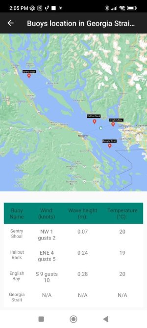
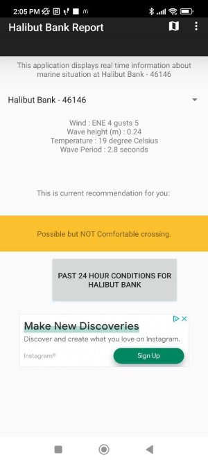
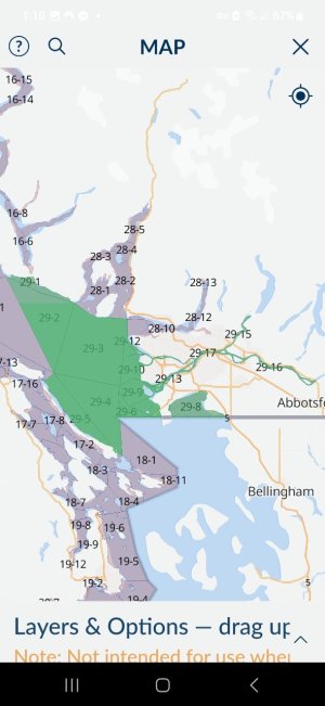
  • Detailed info for each of the 4 buoys in Georgia Strait.
  • Summary view in Georgia Strait (Map icon in the top right corner).
  • Historical view for each buoy.
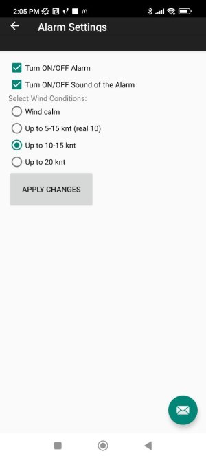
  • Conditions alarm (alerts me when good days are coming).
Please expect bugs in the app since I’m not a professional software developer.

How does it work?

I scrape data for all 4 buoys, both for real-time conditions (the latest reported conditions) and historical data for each buoy.

The alarm simply scrapes data from the North of Nanaimo page: https://weather.gc.ca/marine/forecast_e.html?mapID=03&siteID=14301 and based on that, it calls the user (expect bugs here).

The alarm is hardcoded to trigger every 12 hours, but for some reason, it works for about 1.5 days, and then it seems like the Android system kills the process. However, once you open the app again, it checks if the alarm service is running. If it isn’t, it triggers the process again; if it is still running, it does nothing.

From my personal observations, setting the alarm for 10-15 kt wind indicates a fishable day—not perfect, but manageable.

Known issue: It treats "Tonight" and "Tomorrow" as one element. So, if today isn’t great (e.g., contains 20 kt wind), but tomorrow is perfect, the app won’t notify you, and you might miss out on tomorrow. I’m planning to fix this later.

It doesn’t replace other weather apps—I still rely on Windy a lot—but, for example, when I’m planning to go out, the first thing I do in the morning is open the app and check the wave height at Halibut Bank and English Bay. I also do the same at the boat launch right before launching my boat.

It’s happened to me many times that I get distracted by other activities and miss out on good days. I discover a perfect day after the fact, when it’s already over, and I wasn’t ready. The alarm should help me pay attention to upcoming good days and plan accordingly.

Criticism and suggestions are welcome in this thread.
- https://sportfishingbc.com/threads/...android-app-for-local-vancouver-waters.92737/

Yes I do run ADS as part of self-development on how to implement it and if I'll make $6 over next year for a pack of green hoochies I would feel rewarded lol
 

Attachments

  • photo_2024-08-05_14-05-49.jpg
    photo_2024-08-05_14-05-49.jpg
    35 KB · Views: 18
  • photo_2024-08-05_14-05-50.jpg
    photo_2024-08-05_14-05-50.jpg
    94.2 KB · Views: 19
  • photo_2024-08-05_14-05-55.jpg
    photo_2024-08-05_14-05-55.jpg
    59.6 KB · Views: 18
Well thrasher is certainly on fire. Boxed 4 springs between 7:30-9am this morning and lost a few more. NW of the Rock in 200-300’ of water just keeping a tight circle tack, riggers at 160-170 and pretty much non stop action. Running herring above dummy flashers and the last one on a plug. Bonus hatch coho down deep too. Time to see if there’s any lings left over here.
 

Attachments

  • IMG_6129.jpeg
    IMG_6129.jpeg
    375 KB · Views: 139
  • IMG_6124.jpeg
    IMG_6124.jpeg
    264.2 KB · Views: 138
Well thrasher is certainly on fire. Boxed 4 springs between 7:30-9am this morning and lost a few more. NW of the Rock in 200-300’ of water just keeping a tight circle tack, riggers at 160-170 and pretty much non stop action. Running herring above dummy flashers and the last one on a plug. Bonus hatch coho down deep too. Time to see if there’s any lings left over here.
Great thanks for the report. We’re out now, bunch of unders at entrance, and a few solid wild coho. Looking to head to thrasher soon.
 
Well thrasher is certainly on fire. Boxed 4 springs between 7:30-9am this morning and lost a few more. NW of the Rock in 200-300’ of water just keeping a tight circle tack, riggers at 160-170 and pretty much non stop action. Running herring above dummy flashers and the last one on a plug. Bonus hatch coho down deep too. Time to see if there’s any lings left over here.
Yeah they were liking the plugs on Sunday afternoon
 
Such a loaded question. Anyone keeping chinook at Sandheads right now is not following the regulations.
28-9 opens August 12th.

View attachment 109265
Thanks for the heads up guys.
Still can't find a way on the app here to get the hatching specific to Chinook closures and the legend that is in this photo.
As per the screenshots I have attached here I select Chinook salmon for 29.3 and then click on the interactive map and I just get a whole green area here as you can see without any legend explaining what the green area means.
 

Attachments

  • Screenshot_20240813_130934_FishingBC.jpg
    Screenshot_20240813_130934_FishingBC.jpg
    102.5 KB · Views: 24
  • Screenshot_20240813_131002_FishingBC.jpg
    Screenshot_20240813_131002_FishingBC.jpg
    98.3 KB · Views: 23
Thanks for the heads up guys.
Still can't find a way on the app here to get the hatching specific to Chinook closures and the legend that is in this photo.
As per the screenshots I have attached here I select Chinook salmon for 29.3 and then click on the interactive map and I just get a whole green area here as you can see without any legend explaining what the green area means.
There's no map on the app. But it's pretty clear that it's closed in the described area...
Screenshot_20240813_132304_FishingBC.jpg
 
Back
Top