Aces
Well-Known Member
He is? Can’t wait for his colorful report!
He is? Can’t wait for his colorful report!

Bright one on the right red.number 2 70 on the rigger bait 175 boats in the tick of itView attachment 120754
There were a lot of boats there when we drove through on the way to sand heads at first light. I’m checking a couple of social media pages I am on, not a lot of reports yet. A guest just got a hatchery Coho right at the surface when he was letting his anchovy down. Nice and shiny.Anyone having success at T10? Or all sandheads

Haven't seen a ton caught at sandheads this morning. We got lots of action with pinks, kept a couple. Once nice coho but no Chinook for us. Just heading to try the t10 for a bit.
Fishing anchovies anywhere between 40-129 feet since 7am.
Started in no man's land, worked out way into the pack for the last few hours. Sometimes it just doesn't work out. Also found some dog fish, probably trolling a bit slow?Fishing out in no man’s land ?
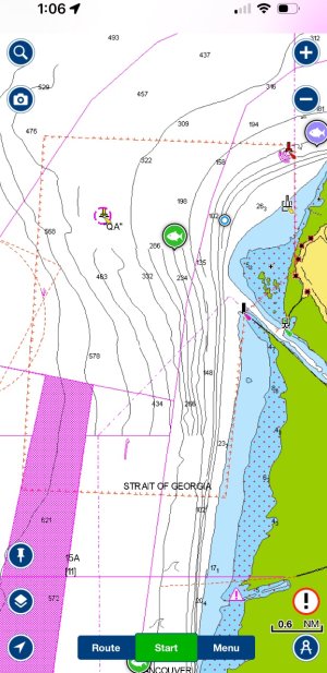
It’s in the Navionics app (dashed line)Looks like I'll be out with kids and guests tomorrow midday. Maybe only going as far as the Bell Buoy. Maybe all the way (!!) to T10.
Where can I find the GPS coordinates or some official description of the boundaries of the SRKW zone off the North Arm? This super-helpful map (not a chart!) only lays out the yellow box but doesn't give exact boundaries.
Management measures in the Fraser River Mouth to support Southern Resident killer whale recovery | Pacific Region | Fisheries and Oceans Canada
Management measures in the Fraser River Mouth to support Southern Resident killer whale recoverywww.pac.dfo-mpo.gc.ca
It’s in the Navionics app (dashed line)
Upper boundary is the Bell (then a line due west)Thanks. I'll save your pic to my phone. Hopefully my new Garmin unit has the SRKW zone marked (the Garmin does have RCAs which is a nice feature that I didn't expect to have!)
Lol yeah it was a Stizzla kind of lead loss show but it was the captain this time. I didn’t throw a rod in the water or anything.im sure we will hear lots about the loss of alot of lead lol @Stizzla
3 balls? You've gotta be kidding meLol yeah it was a Stizzla kind of lead loss show but it was the captain this time. I didn’t throw a rod in the water or anything.
3 balls were sheared of or dropped. You know is how it goes when you lose one, you lose three!
ride over was incredible! Flat calm. Got in around 8 and it was a tough go for about 4-5 hours with nobody really hooking up.
We did get a window of under an hour with some action. Landed 2 springs 8 and 15 ish. One better hit off above the flasher. Add it to the tab I guess :/
Let go a few hatch go’s and met some nice people on other boats. Combat fishing is tricky tho. Probably 300+ boats out.
Sun and good tunes and friends. Any time I fish I love it!
If you only lose 2 cannon balls to the bottom that’s not too bad a day. Then when you go to replace a ball the dam things roll off the side of the gunnel before you get the clip done up, which doesn’t really count in the official tally?Lol yeah it was a Stizzla kind of lead loss show but it was the captain this time. I didn’t throw a rod in the water or anything.
3 balls were sheared of or dropped. You know is how it goes when you lose one, you lose three!
ride over was incredible! Flat calm. Got in around 8 and it was a tough go for about 4-5 hours with nobody really hooking up.
We did get a window of under an hour with some action. Landed 2 springs 8 and 15 ish. One better hit off above the flasher. Add it to the tab I guess :/
Let go a few hatch go’s and met some nice people on other boats. Combat fishing is tricky tho. Probably 300+ boats out.
Sun and good tunes and friends. Any time I fish I love it!