2021 Gulf Island Reports

It's only open for catch and release right no, so there might not be many people fishing.

Oh crap, re-read my message and see I completely forgot to put some detail in there...

We're looking for any Crabbing and Prawning reports... Just wanting to drop a couple traps while we run the winter bugs out of the boat... lol
 
Oh crap, re-read my message and see I completely forgot to put some detail in there...

We're looking for any Crabbing and Prawning reports... Just wanting to drop a couple traps while we run the winter bugs out of the boat... lol
Crabbing for me the last 2 times has been extremely slow. Lots of red rocks but having a very hard time finding dungies in our usual spots. Interested to hear how others are doing for crab
 
Crabbing for me the last 2 times has been extremely slow. Lots of red rocks but having a very hard time finding dungies in our usual spots. Interested to hear how others are doing for crab
When in doubt, try deeper. Or shallower. I havnt been out in a few months so I don't have any current answers for you.
 
Crabbing for me the last 2 times has been extremely slow. Lots of red rocks but having a very hard time finding dungies in our usual spots. Interested to hear how others are doing for crab
After years in the same spots on the outside (off Mayne) and then running dry (of Dungeness) I finally tried some new spots this spring. I’m pretty stubborn with change... anyways, last time out we hit about 20 keeper Dungeness in 3 traps in 2 - 8hr sets. Of course not going to give up my honey hole, but in the Navy channel. So crabbing’s been awesome for me so far this year
 
Ling report! hammered on them this weekend all around the gulf islands. Fished reefs all around Salt Spring; Pender; Galiano, etc. Spent 2 days exploring new areas and ended up with daily/possession limits (1/2) for our crew of 3. Used a mix of jigs/power paddles/ and live bait and had to send back several hogs (20+ lbers) before bonking our preferred 10lb size. Tried new reefs in 30-80ft of water and found them both in the shallows and down deep. Didn't stay at one spot long. If they weren't they we moved on quickly. Lots of RCA's to navigate so we made sure to have Navionics fired up on ipad so that we could clearly see the RCA boundaries.

Can't believe it's come down to a lingcod report for me at this time of year but it is what it is. Hopefully salmon news / openings coming soon.
im trying porlier pass on wednesday see what happens for lings
 
Didn’t end up hitting porlier fished thrasher it was slow not one hit
Thrasher gets beat up in waves. Sometimes takes time for new guys to move into the territory where fish were taken from. Might need a cooling off period. I explored further on Tuesday.
 
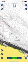
Hey thought I'd just post this here for other as I just got a message asking about how to use navionics to see where RCA's are and I'm sure there are others who aren't super familiar with the navionics app for this use. First, make sure you've downloaded the most recent 'maps' (their word) by opening the navionics app and then clicking on 'Menu' -> 'Update Maps'.

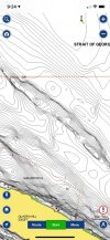
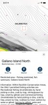
Next just zoom in to an area and you can start to see the red-dashed lines that will indicate the RCA boundaries. Zoom in a little more and you'll see these little pink icons that look like little birds. These little pink birds inside the red-dashed lines indicate the RCA zone. For more details, you can tap your screen within the RCA so that your 'cross hairs' come up and then click on the '?' and then (in this case) click on 'Galiano Island North' and it will give you the image below with the RCA detailed description. Hope that helps. Back to the ling reports!

rca1.jpgRCA2.jpgrca3.jpg
 
Hey thought I'd just post this here for other as I just got a message asking about how to use navionics to see where RCA's are and I'm sure there are others who aren't super familiar with the navionics app for this use. First, make sure you've downloaded the most recent 'maps' (their word) by opening the navionics app and then clicking on 'Menu' -> 'Update Maps'.

Next just zoom in to an area and you can start to see the red-dashed lines that will indicate the RCA boundaries. Zoom in a little more and you'll see these little pink icons that look like little birds. These little pink birds inside the red-dashed lines indicate the RCA zone. For more details, you can tap your screen within the RCA so that your 'cross hairs' come up and then click on the '?' and then (in this case) click on 'Galiano Island North' and it will give you the image below with the RCA detailed description. Hope that helps. Back to the ling reports!

View attachment 65671View attachment 65672View attachment 65673
Thanks tincan, very informative
 
Another great (and free) app to determine if you are in an RCA is the Mycatch by Anglers Atlas app. It will show your location when you enable it and it has all of the RCA's.
 
Hi all, just getting ready to moor my boat at Thieves Bay Marina. I guess the only fishing available now is ling or legal bottom fish.
I am reaching out for info as to where my closest crabbing spots would be. Otter Bay ?, but any other locations would be great
I know to keep my distance and would never drop near other traps. I'm guessing all the best spots are on the west side of the island :(
Thanks for any intel
Shingle Bay, just north of Thieves Bay can produce crabs. Bedwell Harbour and the channel leading to Browning are both popular for crabbing but a bit of a hike from Thieves Bay.
 
Shingle Bay, just north of Thieves Bay can produce crabs. Bedwell Harbour and the channel leading to Browning are both popular for crabbing but a bit of a hike from Thieves Bay.
Thanks carpeweekend for replying with that info. I may have to trailer over to that side once in a while or whenever I gas up.
 
Spent a few days around Saturna and Mayne this week. Prawning was good when the poachers weren't around.. Had my traps messed with twice, the second time the stole all my weights out of them? Make zero sense, very disappointing to see this in the Gulf islands. Never usually have issues over there. Tried quite a bit for some ling cod and couldn't drum one up. Excellent weather though.
 
Spent a few days around Saturna and Mayne this week. Prawning was good when the poachers weren't around.. Had my traps messed with twice, the second time the stole all my weights out of them? Make zero sense, very disappointing to see this in the Gulf islands. Never usually have issues over there. Tried quite a bit for some ling cod and couldn't drum one up. Excellent weather though.
I had my traps stolen there last weekend. I live on Pender. Disappointing
 
Back
Top