
You are using an out of date browser. It may not display this or other websites correctly.
You should upgrade or use an alternative browser.
You should upgrade or use an alternative browser.
Chilcotin Slide
- Thread starter IronNoggin
- Start date
IronNoggin
Well-Known Member
video from a helicopter overflight of the slide area today. Starts below the slide so the degree of dewatering and seepage under the slide is visible.
Yesterday at 3:30pm.
The water has risen substantially in the past 24 hours and change...
The Province now expects the dam will likely not experience a rapid collapse but that the river will top the dam, flow over it and slowly erode it away.

 www.theglobeandmail.com

 globalnews.ca
good news for people near the river but perhaps not so good for fish.
B.C. landslide likely to be flushed down river without need for major evacuations, officials say
How the massive landslide currently blocking the Chilcotin River will affect one of the province’s most important salmon runs remains uncertain
www.theglobeandmail.com
B.C. landslide: Water will take 12 to 24 hours to reach Hope when dam breaches | Globalnews.ca
Concern continues to grow over the Chilcotin River landslide in B.C.'s Central Interior, which has created an unstable dam holding back thousands of litres of water.
globalnews.ca
good news for people near the river but perhaps not so good for fish.
wildmanyeah
Crew Member
wildmanyeah
Crew Member
تسجيل الدخول إلى فيسبوك
قم بتسجيل الدخول إلى فيسبوك لبدء المشاركة والتواصل مع أصدقائك وعائلتك والأشخاص الذين تعرفهم.
 www.facebook.com
IronNoggin
Well-Known Member
CHILCOTIN SLIDE UPDATE, 3 P.M., SATURDAY, AUG. 3
The province just held an information briefing about the slide on the Chilcotin River, so since there's obviously interest in it, here's an update about where we are.
Lidar data has established that the slide is 1,000 metres long by 800 metres wide by 30 metres deep. Lidar is a method for determining ranges by targeting an object or a surface with a laser and measuring the time for the reflected light to return to the receiver.
The 'lake' behind the slide site is rising at a rate of about 22 centimetres per hour. This is a slight decrease over the first couple of days, as the water now has more room to spread out behind the slide area.
There is no seepage at the toe of the slide, so overtopping of the slide is the most likely scenario based on what is known/being observed.
Worst Case Scenario: A one-hour breach scenario. In this scenario it would take 1.5 hours for water to reach Farwell Canyon, three hours to reach the confluence of the Chilcotin with the Fraser, 15 hours to reach Lillooet, 21 hours to reach Lytton, 24 hours to reach Boston Bar, and 29 hours to reach Hope (all times measured from the slide site).
In this scenario, peak flow between the slide site and Farwell Canyon would be 6,590 cubic metres per second (typical freshet flow is 300 cubic metres per second). Peak height above current would be 10 metres. At the confluence with the Fraser the peak flow would be 5,545 cubic metres per second and peak height above current would be four metres.
By the time the flow reached Lillooet it would be well below typical freshet flow but 1.8 metres above the current height. Same at Lytton, where it would 1.5 metres above current height; Boston Bar (1 metre above current height); and Hope, where the water would be 0.3 metres above current height.
Best Case Scenario: A 24-hour breach scenario. In this case, the water would take 9.5 hours to reach Farwell Canyon, and 11 hours to reach the confluence with the Fraser, where the peak height would be 2.1 metres above current.
It was stressed that this is an extremely dynamic situation, and that a lot of assumptions have had to be made to create the models. There is confidence, however, that there will be overtopping, and not a breach. Additional field data is being collected continuously, and all possibilities are being prepared for.
Debris may be part of the outflow, which could damage riverbanks and infrastructure. An evacuation order has been issued for properties along the Chilcotin River from Hanceville to the Fraser, and people are being warned to stay clear of the land and air space around the slide.
A question that has been asked is 'Will there be an effect on area highways?' The answer is 'No.' Highways 20, 99, and 1 are either far enough away from, or too high above, the Chilcotin and Fraser Rivers to be affected.
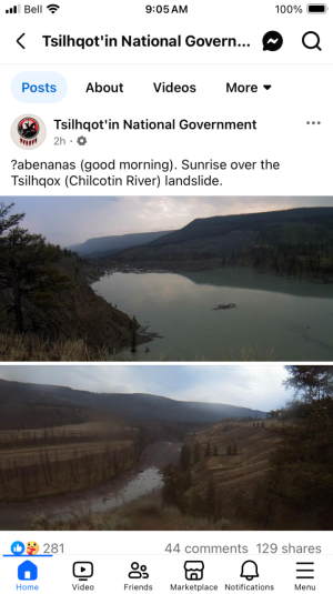
Attached picture (courtesy Marty Lauren/Facebook) shows water and debris backing up behind the slide site (l).

 www.facebook.com
The province just held an information briefing about the slide on the Chilcotin River, so since there's obviously interest in it, here's an update about where we are.
Lidar data has established that the slide is 1,000 metres long by 800 metres wide by 30 metres deep. Lidar is a method for determining ranges by targeting an object or a surface with a laser and measuring the time for the reflected light to return to the receiver.
The 'lake' behind the slide site is rising at a rate of about 22 centimetres per hour. This is a slight decrease over the first couple of days, as the water now has more room to spread out behind the slide area.
There is no seepage at the toe of the slide, so overtopping of the slide is the most likely scenario based on what is known/being observed.
Worst Case Scenario: A one-hour breach scenario. In this scenario it would take 1.5 hours for water to reach Farwell Canyon, three hours to reach the confluence of the Chilcotin with the Fraser, 15 hours to reach Lillooet, 21 hours to reach Lytton, 24 hours to reach Boston Bar, and 29 hours to reach Hope (all times measured from the slide site).
In this scenario, peak flow between the slide site and Farwell Canyon would be 6,590 cubic metres per second (typical freshet flow is 300 cubic metres per second). Peak height above current would be 10 metres. At the confluence with the Fraser the peak flow would be 5,545 cubic metres per second and peak height above current would be four metres.
By the time the flow reached Lillooet it would be well below typical freshet flow but 1.8 metres above the current height. Same at Lytton, where it would 1.5 metres above current height; Boston Bar (1 metre above current height); and Hope, where the water would be 0.3 metres above current height.
Best Case Scenario: A 24-hour breach scenario. In this case, the water would take 9.5 hours to reach Farwell Canyon, and 11 hours to reach the confluence with the Fraser, where the peak height would be 2.1 metres above current.
It was stressed that this is an extremely dynamic situation, and that a lot of assumptions have had to be made to create the models. There is confidence, however, that there will be overtopping, and not a breach. Additional field data is being collected continuously, and all possibilities are being prepared for.
Debris may be part of the outflow, which could damage riverbanks and infrastructure. An evacuation order has been issued for properties along the Chilcotin River from Hanceville to the Fraser, and people are being warned to stay clear of the land and air space around the slide.
A question that has been asked is 'Will there be an effect on area highways?' The answer is 'No.' Highways 20, 99, and 1 are either far enough away from, or too high above, the Chilcotin and Fraser Rivers to be affected.
Attached picture (courtesy Marty Lauren/Facebook) shows water and debris backing up behind the slide site (l).
Ashcroft, BC | CHILCOTIN SLIDE UPDATE, 3 P.M., SATURDAY, AUG | Facebook
CHILCOTIN SLIDE UPDATE, 3 P.M., SATURDAY, AUG. 3 The province just held an information briefing about the slide on the Chilcotin River, so since there's obviously interest in it, here's an update...
www.facebook.com
wildmanyeah
Crew Member
As of 12:40 August 4th, the river remains completely blocked and a large lake continues to form behind the blockage.
As a result of the landslide, the River Forecast Centre has issued Flood Warning and Flood Watches for portions of the Chilcotin and Fraser Rivers. Multiple Evacuation Orders and an Evacuation Alert have been issued in these areas. For more information about the Chilcotin River Landslide event and associated issuances, go to https://www.emergencyinfobc.gov.bc.ca/event/31july24a/
Provincial personnel and external experts are assessing and monitoring the landslide 24/7 as part of a multi-agency coordinated response. Decisions are being guided by ongoing technical modelling and mapping, geotechnical assessments, remote sensing technology, Light Detection and Ranging (Lidar) data and environmental impact assessments.
The Province is continuing to co-ordinate with local authorities, First Nations and the federal government.
For daily updates on the current situation, go to the Resources page to find the latest Information Bulletins, presentations and more.
wildmanyeah
Crew Member
Water expected to overtop Chilcotin landslide tonight, early tomorrow
Share
Information Bulletin
Victoria
Sunday, August 4, 2024 4:40 PMWith the assistance of external experts, B.C. government staff continue to monitor the Chilcotin River landslide 24/7, conduct aerial survey flights and gather additional technical data.
The Province has also just launched a web portal to share the latest information about the slide with the public.
Based on current modelling, it’s expected that water will start to move over (overtop) the blockage late on Sunday, Aug. 4, 2024, or early on Monday, Aug. 5, 2024, and enter the riverbed below the slide site.
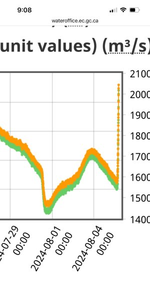
There has been minimal seepage of water through the natural dam created by the landside on Tuesday, July 30, 2024, so the water level behind the dam has continued to increase steadily in recent days. It is rising at a rate of about 18 centimetres per hour.
As refinement of data continues, inputs into the 2D model have allowed for updates to the model. The best and more-likely scenario is still that it would take 12 to 24 hours for the trapped water to move through and past the blockage. This is expected to result in flows below typical freshet (spring flooding) peaks on the Fraser River, though far above freshet peaks on the Chilcotin River. In the 12-hour scenario, the peak flows in the Chilcotin River could be over 10 times greater than a typical freshet peak flow. In the 24-hour scenario, the peak flow could be over seven times greater than a typical freshet peak flow.
In the worst-case scenario, where the lake behind the dam drains very rapidly (within one hour), updated modelling shows higher flows than presented yesterday: significantly higher on the Chilcotin River, and flows at or below freshet flows on the Fraser River. In this scenario, the water in the Chilcotin River could potentially rise to 21 metres at the Farwell Canyon bridge and 12 metres where the Chilcotin River meets the Fraser River. Peak flows in the Fraser River at Lillooet could be similar to or just above a typical freshet-peak flow. The peak flow could take 12-13 hours to reach Lillooet. Communities have been provided with the updated modelling.
Though similar to elevation of heights during freshet flows, the water will react differently, with greater momentum and force, than a gradual increase in water levels.
People are urged to keep out of the Chilcotin River valley between Hanceville and the confluence of Fraser River. An evacuation order issued by the Cariboo Regional District remains in place. People are also advised to stay away from the banks of the Fraser River. Planning continues to address potential impacts of debris as it relates to public safety.
Risks to public safety include the potential for further landslides upstream of the natural dam and downstream of the dam once water begins to flow past it.
The landslide incident poses potential impacts to spawning salmon and other fish species. The Province is working with First Nations and Fisheries and Oceans Canada to establish an incident command structure, mobilize resources and plan mitigation efforts.
The Province is preparing for all possible outcomes since modelling does not provide guarantees. Provincial personnel and partnering agencies continue to work day and night to gather real-time information from the site, to prepare for any mitigation that may be necessary, and to keep people in British Columbia informed and safe. The Province will continue to share the latest information with the public as it becomes available.
As water makes its way down the Chilcotin River and Fraser River, the Province will monitor water levels and will continue to provide updates. Real-time water-level monitoring information is publicly available through the Water Survey of Canada: https://wateroffice.ec.gc.ca/
New web portal for Chilcotin River landslide information:
The B.C. government has created a new web portal to share information about the Chilcotin River landslide with the public and members of the media.
This site includes photos and video of the landslide site and nearby areas; information bulletins issued to date by the Ministry of Emergency Management and Climate Readiness and the Ministry of Water, Land and Resource Stewardship; a link to updates issued by the River Forecast Centre; mapping information and additional resources.
Learn More:
To view the new web portal for Chilcotin River landslide information, visit: https://gov.bc.ca/landslide
wildmanyeah
Crew Member
An important update on the Chilcotin River landslide. The BC Government staff with the assistance of external experts continue to monitor the Chilcotin River landslide 24/7.
While water levels have continued to rise overnight, the water trapped behind the natural dam has not yet reached the top.
However, experts expect water will reach the top and start flowing into the riverbed in the next several hours.
People are urged to keep out of the Chilcotin River valley between Hanceville and the confluence of Fraser River. An evacuation order issued by the Cariboo Regional District (CRD) remains in place, and the CRD has also issued two new evacuation orders overnight due to the risk of flooding resulting from the landslide. For the latest on evacuation alerts and orders please visit https://www.emergencyinfobc.gov.bc.ca/
Planning continues to address potential impacts of debris as it relates to public safety.
We will provide a further update later today. The public can also find the latest information about the landslide at
Attachments
SpringVelocity
Crew Member
here it comes....
wildmanyeah
Crew Member

wildmanyeah
Crew Member

wildmanyeah
Crew Member

wildmanyeah
Crew Member

wildmanyeah
Crew Member
Video
www.facebook.com
تسجيل الدخول إلى فيسبوك
قم بتسجيل الدخول إلى فيسبوك لبدء المشاركة والتواصل مع أصدقائك وعائلتك والأشخاص الذين تعرفهم.
www.facebook.com
IronNoggin
Well-Known Member
Breached:
IronNoggin
Well-Known Member
IronNoggin
Well-Known Member
Similar threads
- Replies
- 8
- Views
- 1K
- Replies
- 5
- Views
- 2K
- Replies
- 0
- Views
- 952
- Replies
- 0
- Views
- 2K