Chilcotin Slide

IronNoggin

Well-Known Member
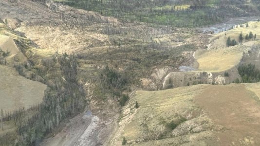
Shocking development as the Chilcotin River suffers massive slide causing complete blockage:

VnAq653.jpeg


fQHTJdj.jpeg


Real-Time Hydrometric Data Graph for FRASER RIVER AT BIG BAR CREEK (08MD013) [BC]​


qlUGQBv.jpeg


Landslide blocking Chilcotin River, RCMP expediting evacuation order​


BREAKING: Reports of landslide, 1 injured along Chilcotin River​


‘Imminent risk’: Evacuation order issued due to Chilcotin River landslide​


Many more pictures and descriptions in the above noted links
 
Will be interesting what they decide to do I would think digging controlled release might be safer then letting a lake build up until it blows

Maybe no time for that tho
 
I would think that time is of the essence. Either have to somehow make an opening for controlled release or send in the military planes for some target practice. The more water allowed to build up the worse it’s gonna be when it lets go imo
 
Listened to the news conference at noon with Minister's Ma and Cullen and there are reports water is seeping out under the base of the slide which could mean an early penetration by the river & collapse ...there is also now a higher water alert for the Fraser below Hope to Vancouver. Hopefully we will get a warning. Close to the site there may not be.


First Nation chief says B.C. landslide doubled in size, sparks concerns​


The chief of Williams Lake First Nation says a landslide of debris that has dammed the Chilcotin River in British Columbia's central Interior has nearly doubled in size since Wednesday.

Chief Willie Sellars, who toured the slide site by helicopter Wednesday and Thursday, says the water is continuing to build on one side of the dam, while the other had "completely dried up" for about two kilometres.

Officials have said the water collecting behind the slide south of the city of Williams Lake could reach a level where it will start flowing over the debris, or it will erode the material, setting off a release.

They have estimated a release could come Friday or Saturday, and could set off dozens of evacuation orders and alerts downstream.

Evacuation orders span 107 square kilometres along the Chilcotin, and officials saying the slide poses an "immediate danger to life and safety."

The nearby Tsilhqot'in National Government has declared a state of local emergency and warned people to stay away from the river.

The state of the river also has Interior Health relocated 21 patients out of a hospital and long-term care home in Lillooet to alternate areas.

Sellars says his community is about 45 minutes away from the slide, so an evacuation of the community likely won't be necessary.

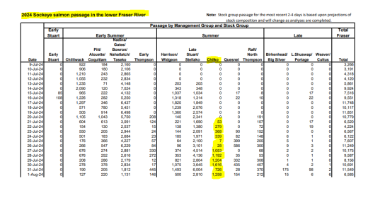
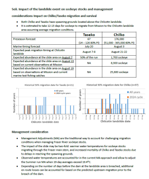
However, he says the region is of "massive cultural significance" to First Nation communities in the region, noting the slide will also affect navigation channels for salmon.

"(There's) a lot of history, former village sites, burial grounds, and we need to make sure that we're doing everything we can to document and protect those," he says.

Sellars says "it's hard to describe in words how massive this slide is, and how devastating it is," adding he hasn't received updated projections yet on when the dam may break.

"We want to get more information out and you know, our team is on it, and working collaboratively with the (Cariboo Regional District), the province and the federal government and I'm feeling very confident that we're going to have that information soon."


chilcotin-river-landslide-1-6987310-1722609507300.jpeg
 
Chilco􀆟n Landslide event, Tributary to the Fraser River Watershed
(Williams Lake, Bri􀆟sh Columbia)

• On July 31 a significant landslide event occurred in the lower Chilcotin River, approximately 28
km upstream from the confluence with the Fraser River.
• The site is located approximately 65 km southwest of Williams Lake, British Columbia and on
Tsilhqot'in National Government title land.
• The landslide resulted in deposit of a large volume of debris which has blocked the entire width
of the Chilcotin River for several hundred meters, which is impounding water upstream.
• The site is currently highly unstable and the area is under mandatory evacuation order.
• In response, First Nation and Provincial governments have enacted emergency management
measures (supported by relevant Canadian federal agencies).
• The Chilcotin River supports several important populations of Pacific salmon, with all major
spawning sites for Chinook, sockeye and coho salmon located upstream of the site. Specific
stocks originating from the Chilcotin watershed include:
o Taseko Chinook (Summer 5,2 Chinook)
o Elkin Chinook (Summer 5,2 Chinook)
o Upper Chilcotin Chinook (Spring 5,2 Chinook) – Enhanced/hatchery
o Lower Chilcotin Chinook (Spring 5,2 Chinook) – Enhanced/hatchery
o Chilko Chinook (Summer 5,2 Chinook) – Enhanced/hatchery
o Chilko Sockeye (South end, north end and river populations)(Summer run)
o Yohetta Sockeye (Early Summer run)
o Chilcotin Sockeye
o Taseko Sockeye (Early Summer run) – Enhanced/hatchery
o Chilko Coho
o Chilcotin Coho
o Chilcotin Steelhead (Summers)
1722623856684.png
 
Back
Top