Fires 2025

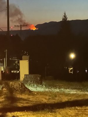
2025 Mount Underwood Wildfire​

Current situation

August 21, 2025

The Mount Underwood Wildfire is now BEING HELD!!

This fire status does not mean the fire is out. BC Wildfire changes the status from Out of Control to Being Held when a wildfire is projected, based on fuel and weather conditions and resource availability, to remain within the current perimeter, control line or boundary.

The Mount Underwood Wildfire is currently 3,548 hectares. Over the past week, approximately 40 mm of rain has fallen in the vicinity of the Mount Underwood Fire. Fire behaviour and activity has been minimal on this incident, primarily Rank 1 – a smoldering ground fire with no open flame.

Crews are continuing mop-up operations along the North flank. On the east flank, firefighters are patrolling up to 100 feet along the perimeter to extinguish hot spots. In the southern sections, rappel crews have established access, allowing firefighters to patrol and mop up a 100-foot zone. Crews are digging into the forest floor to expose and extinguish smoldering hot spots within 100 feet of the fire’s edge. They now are able to access all four flanks of the fire and are continuing to push containment around the perimeter.

The Franklin River Road between Port Alberni and Bamfield remains closed. Check DriveBC for updates on road closure.

The Youbou route to Bamfield remains open, and Bamfield announced yesterday that it was open for business. The community is welcoming back visitors, but asking them to be prepared for the road conditions and ready for some restrictions the power outage may create. Not all businesses are open, so make sure to check in with your accommodations before heading to Bamfield.

The Alberni-Clayoquot Regional District (ACRD) Emergency Operations Centre (EOC), in coordination with BC Wildfire Service, the City of Port Alberni, and Tseshaht First Nation, downgraded and updated the Evacuation Order and Evacuation Alerts, issued due to the Mount Underwood Wildfire on August 12, 2025. For full details refer to the Evacuation Alerts and Orders section below, or go to 20-08-2025 Mount Underwood Evacuation Alerts and Order update News Release


A bird’s-eye view of the newly rebuilt power line following the Mount Underwood wildfire. Crews are making faster-than-expected progress, with 60 new power poles and 62 spans of line already installed. We now expect to have power restored to customers in Bamfield and balaac̓adt a few days ahead of schedule. Read our latest operational update:

View attachment 119995
😎
 

New wildfire north of Yale, B.C., prompts evacuation alert​

A new wildfire north of Yale in B.C.’s Fraser Canyon prompted an evacuation alert on Sunday afternoon.

The Sailor Bar fire, about seven kilometres north of Yale, is mapped at about 50 hectares in size and is out of control.

The Fraser Valley Regional District issued the evacuation order for the area of Yale north to Spuzzum Creek Road, including both east and west sides of the Fraser River.

The alert includes:

Yale, Electoral Area B

Properties on Spuzzum Creek Road

Private Properties on both the east and west side of the Fraser River from Yale north to Spuzzum Creek Road

Crown lands in the mapped area

The fire was discovered late on Aug. 23 and was initially mapped at two to three hectares.

The BC Wildfire Service said a helicopter equipped with night-vision technology worked on the fire overnight but the blaze is in steep, difficult-to-access terrain.

Multiple aviation and ground resources were responding on Sunday.

The fire is burning at Rank 2 intensity, which means a surface fire with visible, open flames and a slow rate of spread, and an unorganized or inconsistent flame front.

CN Rail has closed its tracks in the area.

The BC Wildfire Service said no other infrastructure is immediately threatened.


Campfire bans to take effect in Kamloops, Cariboo fire centres Thursday​

Campfire bans are scheduled to take affect in two large regions of British Columbia later this week.

The BC Wildfire Service says the bans will take effect in the Kamloops and Cariboo fire centres at noon on Thursday.

The bans are being implemented to cut the risk of human-caused wildfires, and come after a stretch of scorching weather.

cariboo.jpg


The bans will remain in effect until mid-October in the Kamloops zone and mid-September in the Cariboo zone.

The ban doesn’t cover CSA- or ULC-rated stoves or devices for outdoor cooking, heat or ambiance that burn charcoal briquettes, or liquid or gaseous fuels and have flames under 15 centimetres.

A campfire ban is already in place for the Coastal Fire Centre.

Anyone caught breaking the ban can be slapped with a ticket for $1,150, be handed an administrative penalty of $10,000 or, if convicted in court, face a $100,000 fine or a year in jail.

 
Back
Top