2022 Gulf Island Reports

Status
Not open for further replies.
hey @Rip Point, yes, there will be a small wrap up event at the restaurant (Crane and Robin) that is attached to the Montague Marine Store. Derby ends at 5pm so that's when it will start and probably be done by 6:30 or 7pm. Everyone in the derby gets an order of tacos, salad and a beer included with their entry fee. We will hand out prizes during dinner as well so hopefully everyone participating can make it for that.
Next year @Rain City has offered up his chicken services! :cool: Looking forward to it!
 
I guess the question is is red included in yellow, and if so, have whales been spotted this year?

If it's closed I may have to reconsider the friendly first nations fellow sitting at Tulista's offer to go fishing....
Until June 1st it is open to non retention fishing at Pender Bluffs just like Fairfax. The SRKW have not shown in Haro Strait until at least July 1st for the past 2 years as thats when the dynamic start has been for shipping involved in the slowdown.
 
Vague on start dates, but good chance it is in effect already.

View attachment 79783
I spoke to a Fisheries Officer at the Sidney boat show last weekend and they indicated that the whales had yet to be seen in the zone so it was still June 1st for now. But they didn't know how people would be notified but assumed that it would be posted? I also asked if there was any way that they could make the regulations a little more confusing. They also happened to mention that while the maps existed, they didn't yet have the actual GPS coordinates for the boundaries of the maps so I suppose it is all just a guess - sorry for the rant/derail. Back to reports.
 
I spoke to a Fisheries Officer at the Sidney boat show last weekend and they indicated that the whales had yet to be seen in the zone so it was still June 1st for now. But they didn't know how people would be notified but assumed that it would be posted? I also asked if there was any way that they could make the regulations a little more confusing. They also happened to mention that while the maps existed, they didn't yet have the actual GPS coordinates for the boundaries of the maps so I suppose it is all just a guess - sorry for the rant/derail. Back to reports.
The Pender zone is regulated by Transport Canada and comes out as a Navwarn it is also displayed on AIS, Not a fisheries item. I understand the final openings document is to be released in June.
 
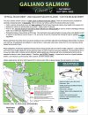
Rules sheet for those in the Galiano derby this Saturday out of Montague Harbour. See you there. Hopefully some nice reports / pics to follow as there hasn't been much in any of these reports threads of late.

2022 Galiano Derby - RULES.JPG
 
Looks like we're done from what I read below


Ops Centre Fishery PAC / Centre des peches du Pacifique (DFO/MPO)


To:
  • You
Wed 2022-05-25 5:26 PM

Category(s):
ABORIGINAL - General Information,
COMMERCIAL - Salmon: Gill Net,
COMMERCIAL - Salmon: Seine,
COMMERCIAL - Salmon: Troll,
RECREATIONAL - General Information,
RECREATIONAL - Salmon


Fishery Notice - Fisheries and Oceans Canada

Subject: FN0500-Southern Resident Killer Whale Recovery - Salmon Fishing Closures in the Southern Gulf Islands - Effective May 27, 2022 until October 31, 2022

This notice provides information on planned fisheries management measures for the recovery of Southern Resident Killer Whales that will be in place from 00:01 hours May 27, 2022 until 23:59 October 31, 2022.

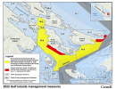
Subarea 18-9, and those portions of 18-2, 18-4, and 18-5 inside a line drawn from Collinson Point on Galiano Island at 48°51.590' N and 123°21.152' W, then easterly to 48°51.450' N and 123° 20.722' W at Helen Point on Mayne Island, then southerly following the shoreline of Mayne Island to 48°50.010' N and 123°19.675' W at Dinner Point, then southerly to 48°49.141' N and 123°19.632' W at Stanley Point on North Pender Island, then southerly following the shoreline of North Pender Island to 48°44.199' N and 123°13.893' W at Wallace Point, then easterly to 48°43.951' N and 123°12.489' W at Tilly Point on South Pender Island, then easterly following the shoreline of South Pender Island to 48°44.697' N and 123°10.467' W at Teece Point on South Pender Island, then northeasterly to 48°45.817' N and 123°09.319' W at Murder Point on Saturna Island, then easterly following the shoreline of Saturna Island to 48°46.967' N and 123°02.733' W near Saturna Island Sector Light, then southeasterly to a point in water at 48°46.934' N and 123°02.665' W, then southwesterly to a point in water at 48°46.558' N and 123°03.147' W, then southwesterly to a point in water intersecting with the international boundary with the United States of America at 48°44.866' N and 123°04.638' W, then westerly following the international boundary with the United States of America to a point in water intersecting with the international boundary with the United States of America at 48°43.063' N and 123°11.026' W, then southwesterly following the international boundary with the United States of America to a point in water intersecting with the international boundary with the United States of America at 48°41.640' N and 123°16.073' W, then southerly following the international boundary with the United States of America to a point in water intersecting with the international boundary with the United States of America at 48°41.269' N and 123°15.948' W, then westerly to 48°41.088' N and 123°17.622' W at Arachne Reef Light, then northeasterly to a point in water approximately 0.5 nautical miles from the shoreline of Moresby Island at 48°42.753' N and 123°16.439' W, then northwesterly to a point in water located approximately 0.5 nautical miles from the shoreline of Moresby Island at 48°44.563' N and 123°18.529' W, then westerly to a point in water at 48°44.263' N and 123°19.142' W, then northwesterly to 48°46.522' N and 123°22.002' W at Beaver Point on Saltspring Island, then northerly to a point at 48°49.285' N and 123°21.301' W on Prevost Island, then northerly following the shoreline of Prevost Island to 48°49.979' N and 123°21.883' W near Porter Bight on Prevost Island, and then northeasterly in a straight line back to the point of commencement.

In addition, all fishing will be prohibited (with some exceptions) from June 1 until November 30, 2022 in the Interim Sanctuary Zones located in portions of Subarea 18-4 (Pender Island) and Subarea 18-5 and 18-11 (Saturna Island). A separate Variation Order and Fishery Notice will be provided in advance of the effective dates.

In addition, fishing is prohibiting in the following areas on the West Coast of Vancouver Island in support of Southern Resident Killer Whale recovery:

Commercial and recreational salmon fishing is prohibited in a portion of 29-3 at the Mouth of the Fraser River from August 1 to September 30, a portion of Subarea 121-1 and 121-2 from July 15 (or following the expiry of the Chinook non-retention measures) until October 31, 2022, and in Subareas 20-1 and 20-5 from August 1 (or following the expiry of the Chinook non-retention measures) until October 31, 2022. A separate Variation Order and Fishery Notice will be provided in advance of the effective dates.

The Southern Resident Killer Whale population is small and declining, with only 72 individuals remaining, not including two new calves reported March and April 2022, and is exposed to a number of anthropogenic threats, including underwater noise and disturbance from vessels. Given the imminent threats the whales are facing, additional management measures are in effect:

Vessels must stay 400m away from killer whales (with some exceptions) in all southern BC coastal waters between Campbell River and just north of Ucluelet until May 31, 2023.

Vessels must travel at no more than 10knots (with some exceptions) from June 1, 2022 until November 30, 2022 in the Seasonal Slowdown Areas located in portions of Subareas 121-1, 121-2 and 21-0.

The Government is also asking vessel operators to respect the following voluntary measures:
-Stop fishing (do not haul gear) within 1000 metres of killer whales and let them pass;
-Reduce speed to less than 7 knots when within 1000 metres of the nearest marine mammal;
-When safe to do so, turn off echo sounders and fish finders; and
-Place engine in neutral idle and allow animals to pass if your vessel is not in compliance with the approach distance regulations

For further information on the suite of Southern Resident Killer Whale mandatory and voluntary management measures, please visit: https://www.canada.ca/southern-resident-killer-whales

FOR MORE INFORMATION:

Marine Mammal Team
DFO.SRKW-ERS.MPO@dfo-mpo.gc.ca


Fisheries and Oceans Canada Operations Center - FN0500
Sent May 25, 2022 at 17:25
Visit us on the Web at http://www.pac.dfo-mpo.gc.ca

If you would like to unsubscribe, please submit your request at: http://www-ops2.pac.dfo-mpo.gc.ca/fns-sap/index-eng.cfm?pg=manage_subscription


If you have any questions, please contact us via e-mail to: DFO.PACOpsCentre-CentredesOpsPAC.MPO@dfo-mpo.gc.ca
 
Shiite, I saw that post but was waiting for someone with a fisheries law degree to explain it to me.
Well I'm no expert but, what I am, is really pissed!! Should have left the boat in Vancouver, at least I could be fishing for Coho and catch and release.
If someone could say I'm wrong I would appreciate a different interpretation.
 
You must be fishing in the North Gulf "Island" as fishing is closed in the Southern Gulf Islands. All fishing, all species.
Please provide a source for that. Recreational and commercial salmon fishing is closed for most of the gulf islands. No catch and release. No fishing for salmon period.

Further in the Sanctuary zones(in red on the map) All fishing is closed.

In the yellow zones you are still allowed to fish for bottom fish and any other non salmon species. (you may still run into trouble if you get caught trolling anchovies and claim to be targeting dog fish…) but I see no regulation anywhere that ALL FISHING is closed.

that being said, I’d rather be corrected by you than a dfo minion on the water.
 
I apologize as I thought I saw it on a map from DFO. This was my source... before this post on facebook I was happy to fish for bottom fish.
Appreciate you correcting me. I will do some additional research as the Trustee who posted on facebook is usually accurate.


Okay Penderites, help me understand something. The feds have closed down all fishing here in the waters around Pender (see map) This includes all salmon species, lingcod, halibut and rock cod. Apparently the goal is to try and protect the spring salmon and the ability for the Southern Resident Killer Whales to forage successfully for them without being bothered by underwater noise and collisions. Meanwhile, the large freighters continue to transit the area on their way to one of the 33 anchorages in the Southern Gulf Islands. They don’t have to go slow to avoid possible collisions with the whales and the noise of their propellers is significant! Something here just doesn’t make sense.

1653753871514.png
A
 
I apologize as I thought I saw it on a map from DFO. This was my source... before this post on facebook I was happy to fish for bottom fish.
Appreciate you correcting me. I will do some additional research as the Trustee who posted on facebook is usually accurate.


Okay Penderites, help me understand something. The feds have closed down all fishing here in the waters around Pender (see map) This includes all salmon species, lingcod, halibut and rock cod. Apparently the goal is to try and protect the spring salmon and the ability for the Southern Resident Killer Whales to forage successfully for them without being bothered by underwater noise and collisions. Meanwhile, the large freighters continue to transit the area on their way to one of the 33 anchorages in the Southern Gulf Islands. They don’t have to go slow to avoid possible collisions with the whales and the noise of their propellers is significant! Something here just doesn’t make sense.

View attachment 80246
A
As a (former) Penderite myself, believe me, they are as upset about the tankers and freighter anhochorages as they are about whales. Mainly for the selfish “oh no I don’t want to see lights out on the ocean from my $5 million waterfront property”

Unfortunately the penderite sport fishing community is small and not very vocal. Pender is a mob culture. Wokest people win. Everyone is already well off and retires so they have nothing better to do. If you try to as much as say that an orca measurement is not effective, unless you say you want to make them broader, you will get stoned. And not in the Saltspring way .

Recreational salmon fishing is closed close to pender. But the only really productive spot on pender In the summer has been the bluffs, they’ve been closed for years it’s death by a thousand cuts. Nothing has really effectively changed for pender since 2018. Fairfax is still open and only a 15 minute run. Yellow areas still allow ling and bottom fishing.

Edit: South Pender took a pretty big hit especially as it took over from the bluffs after they closed. I’m sure Pender fishermen aren’t happy but neither is anyone else south Campbell.
 
Status
Not open for further replies.
Back
Top