What forecast model do you use in Windy and Why

Over the years I have been using a variety of wind forecast models.

Although they are good they are still just an estimate and may or may not be accurate.

So I usually use them but pay attention to pressure changes, weather fronts. Probably the most important is what tides and currents are doing.

Currents have to be the number one thing most boaters don't understand. You can a 5 knot wind with an opposing current and it can be ugly. Colder the day worse it will be.

In South island the most accurate thing for Victoria and Sooke area is the pressure gradient graph on BWD. Larger the pressure swing stronger the wind.
"Colder the day worse it will be.".....interesting factor. What do you mean by that, exactly?
Thanks.
 
Actually, now that's I've played with it a bit, I did find a way to show a "current map", actually, and not just a STATION here and there like I was thinking.
Some day I hope they expand the current map beyond the Southeast half of Vancouver Island - but still pretty helpful, and free.
Their WAVE map is also good, and covers more areas.


View attachment 103816
Anyone know when they (Oceanconnect) will expand coverage to include WCVI? I like the current forecast feature. Right now it seems best we have is Navionics for current forecast on WCVI.
 
Anyone know when they (Oceanconnect) will expand coverage to include WCVI? I like the current forecast feature. Right now it seems best we have is Navionics for current forecast on WCVI.
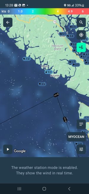
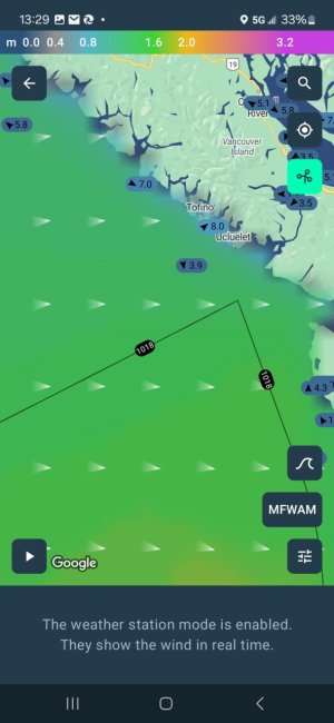
Windy App has it. Both swell and currents
 

Attachments

  • Screenshot_20240306_132812_Windyapp.jpg
    Screenshot_20240306_132812_Windyapp.jpg
    92.1 KB · Views: 15
  • Screenshot_20240306_132906_Windyapp.jpg
    Screenshot_20240306_132906_Windyapp.jpg
    76.5 KB · Views: 15
Anyone know when they (Oceanconnect) will expand coverage to include WCVI? I like the current forecast feature. Right now it seems best we have is Navionics for current forecast on WCVI.
Hey, that's the next big thing we will start working on (in the next week or two) so hopefully it won't be too long!
 
Actually, now that's I've played with it a bit, I did find a way to show a "current map", actually, and not just a STATION here and there like I was thinking.
Some day I hope they expand the current map beyond the Southeast half of Vancouver Island - but still pretty helpful, and free.
Their WAVE map is also good, and covers more areas.


View attachment 103816
Yup @Fishdude the next thing on our roadmap is to cover the entire BC coast!
 
"Colder the day worse it will be.".....interesting factor. What do you mean by that, exactly?
Thanks.

Physics really.

Boyle’s Law – for a given pressure, the density of a gas varies inversely with the temperature – cold air is denser than warm air and so creates a greater force.

Here is a write up on it.

 
Physics really.

Boyle’s Law – for a given pressure, the density of a gas varies inversely with the temperature – cold air is denser than warm air and so creates a greater force.

Here is a write up on it.

Interesting, but I don't think it's something really considered by professional mariners as it's such a minimal consideration at 10% of wind speed
Windage Formula F = (V2 / 18,000) x A F = Force in tonnes / square meter (t/m2) V = Wind Speed in meters / second (m/s) A = Area in Square Meters (m2) = LOA x Freeboard (add accommodation + cargo for total area)
 
Last edited:
I am discovering oceanconnect's currents and thinking they'll be useful. How much faith should I have?
 
I am discovering oceanconnect's currents and thinking they'll be useful. How much faith should I have?
Not sure, maybe someone can provide data on historical accuracy. In the absence of that, only way to find out is to go and see how it compares to real-life conditions, and see if it’s something that you feel you can rely on in and of itself, or use as one of many data points to inform your trip planning.
 
Windy App has it. Both swell and currents
Thx, I looked at the predictions and they appear (to me at least) to be under-estimating the actual currents as compared to Navionics (0.4 mph vs 0.8 mph). Maybe its how I'm interpreting the data presented - any sense or experience with how accurate windy is on current predictions?
 
Thx, I looked at the predictions and they appear (to me at least) to be under-estimating the actual currents as compared to Navionics (0.4 mph vs 0.8 mph). Maybe its how I'm interpreting the data presented - any sense or experience with how accurate windy is on current predictions?
Agreed.
 
Does Navionics show currents in Quatsino Sound? I think not, which is a bummer. Other than that I LOVE Navionics.
Not that I can find on my app. Very limited number of locations where there is current data. Bit challenging to find an app that has reliable/accurate current predictions in most locations along the coast.
 
Did some more looking around and discovered that Predict Wind now offers another new app called Predict Current - which on first review appears to be accurate. This could be a game changer for me.
 
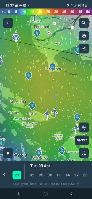
I'm gonna throw this out there one more time.
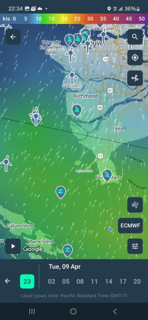
The GFS appears much more accurate once again, as I have 20 knots from the south on the anemometer.
 

Attachments

  • Screenshot_20240408_223412_Windyapp.jpg
    Screenshot_20240408_223412_Windyapp.jpg
    116 KB · Views: 22
  • Screenshot_20240408_223340_Windyapp.jpg
    Screenshot_20240408_223340_Windyapp.jpg
    117.7 KB · Views: 22
I'm gonna throw this out there one more time.
The GFS appears much more accurate once again, as I have 20 knots from the south on the anemometer.

I'm gonna throw this out there one more time.
The GFS appears much more accurate once again, as I have 20 knots from the south on the anemometer.
GFS is fine, but honestly after using this app for over 10 years, anything outside 72 hours is a crapshoot. I have used every model for the Caribbean, Bahamas,Florida , West Coast and Haida Gwaii and the biggest thing I learned was don’t trust anything outside of 3 days and use multiple projections. For me on the west coast of BC and Haida Gwaii ECMWF/GFS+ and HRDPS has been the most accurate. Just my 2 cents.
 
Figure this thread is a relevant place to put this question. I have noticed a couple times, including in the forecast for today and tomorrow, that certain models at certain times will show a wind gust number LOWER than the corresponding steady wind number? For example Winds 15 gusting to 11.

What am I supposed to interpret from that? Best I can figure is a steady blow that is starting to slack off and lose energy.
 
Back
Top