Water Taxi Crash

There's a ton of lodge boats without radars. I didn't have one on any boat I ran the first 5 years I guided in that environment. Don't get me wrong, in hindsight they all should have had them. I remember heading to the island from the northcoast and being surprised mostly all the charter boats had radars.

I highly doubt the mosquito fleet of Udrive boats around Langara run radars. What the point anyway? Many of those folks can't find north on a compass.
in adverse conditions they all may very well be in breach.
 
In adverse conditions your sounder, GPS chartplotter, radar, radar reflector, ( for the other guys ) eyeballs, and common sense are all required. If the instruments are not all singing the same song pull back the throttle and get it figured out long before you end up on the rocks, or crashing into somebody else. It is NOT rocket science. And keep the damn booze on shore where it belongs.
 
Last edited:
In adverse conditions your sounder, GPS chartplotter, radar, radar reflector, ( for the other jerks ) eyeballs, and common sense are all required. If the instruments are not all singing the same song pull back the throttle and get it figured out long before you end up on the rocks, or crashing into somebody else. It is NOT rocket science. And keep the damn booze on shore where it belongs.
You are right but when did common sense ever play a factor?
 
Re the shortcut, there is a reef at the mouth of thormanby Island I'm sure many of you are aware of. Many local cabin owners choose to shoot between the reef and the rock on shore ostensibly to avoid hitting the reef further out towards the bouy. This shortcut saves no time but definitely adds risk. I'm pretty sure it's more of a "look what I can do" thing.
Incidentally, both HiBaller and Bucaneer marina water taxi services go around the far end of the reef (marker bouy) every time.lol
 
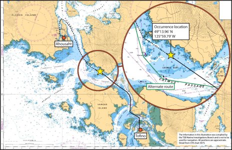
I know the run between Tofino and Ahousat very well. Have done it many times in boats and many hundreds of times in an airplane. There is a rockpile off Catface that all the locals, including taxi's, run straight through as it's the shortest route. While there are tons of yahoo's on that run, I would bet this guy has done the run thousands of times. Radar would be of no use running through a rock pile, this would be all GPS and local knowledge. I would say that the GPS froze comment is just an excuse, he just wasn't paying attention and was complacent.
 
The impact wasn’t in the Chetarpe cut, it was on the standard travel route through that zone. As mentioned, the very experienced captain knew this route like the back of his hand and unfortunately when he lost his gps signal in heavy fog he didn’t power down to solve. I drove through there the day of the crash and it was absolute peasoup fog in January which is very uncommon. It’s very fortunate that hull withstood the massive impact and didn’t sink or this would have been a lot worse.
 
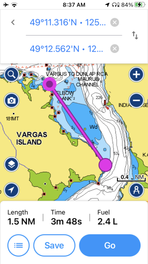
Here’s the other short cut that local and water taxis use heading westbound towards Ahousat and Raphael area. Yeah I found out the hard way to not go this route on a minus tide 🙄
 

Attachments

  • 53E36042-2707-44EE-AAEC-75DF4F44D5A2.png
    53E36042-2707-44EE-AAEC-75DF4F44D5A2.png
    267.3 KB · Views: 36
Back
Top