You are using an out of date browser. It may not display this or other websites correctly.
You should upgrade or use an alternative browser.
You should upgrade or use an alternative browser.
Island Fires
- Thread starter IronNoggin
- Start date
fish brain
Crew Member
Can anyone give an update about the fire potentially heading for Errington?I was just in a meeting regarding the Cameron lake fire and I was told it could be 5-6 days for the highway to open.
IronNoggin
Well-Known Member
I have friends arriving at the nanaimo airport for a charter in uki tommarow, Google maps is saying they can go through a Horne lake route. Is that possible or should I send them through the lake cowichan way?
Horne Lake is not an option at this point.
Perhaps Mosaic will get their crap together and get that operational (should be at all times for emergency use IMO).
For now, only access is via Cowichan...
Nog The Trapped
IronNoggin
Well-Known Member
The pictures I posted earlier are no longer valid.
Mount Arrowsmith and the entire ridge on either side is lost in the smoke.
And the smoke is now wandering into town.
Tough on the throat & lungs!
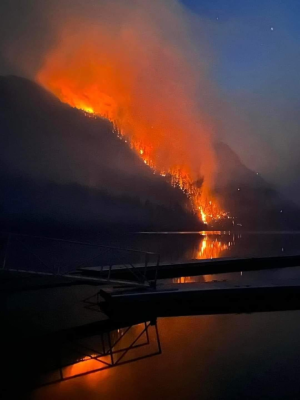
The fire has forced officials to close the only highway to popular Island destinations such as Port Alberni, Tofino and Ucluelet
Nog
Mount Arrowsmith and the entire ridge on either side is lost in the smoke.
And the smoke is now wandering into town.
Tough on the throat & lungs!
B.C. Wildfires 2023: Blaze on Vancouver Island that closed Highway 4 spreading rapidly
The fire has forced officials to close the only highway to popular Island destinations such as Port Alberni, Tofino and Ucluelet
Nog
SpringVelocity
Crew Member
Fak!
Pippen
Well-Known Member
Horne Lake is not an option at this point.
Funny, on Google Maps now it shows a route through Horne Lake when I checked on my phone.
For those who have driven the route through Cowichan how are the roads once you leave pavement through to Alberni?
My wife is VERY stubborn and wants to get to Tofino.
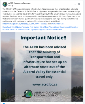
Also to add BC Highways have made it official that Cowichan will be the alternate route.

Highway 4 detour in place due to Cameron Lake Bluff wildfire
Highway 4 remains closed at Cameron Lake Bluff due to wildfire affecting the area.
news.gov.bc.ca
Last edited:
IronNoggin
Well-Known Member
Funny, on Google Maps now it shows a route through Horne Lake when I checked on my phone.
Oh the route itself exists alright.
But Mosaic has gated the hell out of it, and ignored maintenance for years.
be a spell before they can actually get it drive-able.
And I STRONGLY suggest NOT dragging a boat through there if / when they do!
Drove it many a time before the lumber companies began their ignorant gate crusade...
Nog
wolf
Well-Known Member
You know what the wost part here the "new" way of fighting fire is to put a bucket of water on a helicopter, and if the mars were still used instead of the government screwing the lil guy like they did the mars would have to do a few dumploads and probally be contained way better . Its like going to a water gun fight with a lil 2.99 pistol hand held or showing up with a super soaker!!!
I may have to Run up from sooke!!!???
I may have to Run up from sooke!!!???
IronNoggin
Well-Known Member
The alternate route Pippen posted above is now shut down due to a roll-over at the half way mark.
Should be cleared later on today methinks...
Should be cleared later on today methinks...
Unreel
Well-Known Member
Crash was bound to happen on that route, plus that commercial truck was way over sized to be doing that route.The alternate route Pippen posted above is now shut down due to a roll-over at the half way mark.
Should be cleared later on today methinks...
Pippen
Well-Known Member
The alternate route Pippen posted above is now shut down due to a roll-over at the half way mark.
Should be cleared later on today methinks...
If anyone has any updates please post them up as you hear.
SpringVelocity
Crew Member
Same
IronNoggin
Well-Known Member
Crash was bound to happen on that route, plus that commercial truck was way over sized to be doing that route.
Especially when the Notice directly said NO commercial truck traffic!
SpringVelocity
Crew Member
Yep me thinks not going this weekend. 


IronNoggin
Well-Known Member
Appears the highway is going to be closed for a while...
Highway 4 – Cameron Lake – Vancouver Island
Highway 4 is CLOSED in the Cameron Lake area (Koen Road to Cathedral Grove) due to wildfire. Damage to the road and instability of the slope above the highway means this closure is likely to last beyond the fire itself.
 www.tranbc.ca
Highway 4 – Cameron Lake – Vancouver Island
Highway 4 is CLOSED in the Cameron Lake area (Koen Road to Cathedral Grove) due to wildfire. Damage to the road and instability of the slope above the highway means this closure is likely to last beyond the fire itself.
Current Road Advisories and Information | TranBC
Emergency highway messaging for flooding, May 3, 2023
casper5280
Crew Member
Similar threads
- Replies
- 2
- Views
- 1K
- Locked
- Replies
- 25
- Views
- 4K
- Replies
- 3
- Views
- 681
- Replies
- 4
- Views
- 1K


