nedarb2
Active Member
Still on boat, will be removed in 3 weeks. Im now running a laptop gps and depthsounder unit.
Works good, comes with mount, antenna, all cables, and cover. Everything to make it go!
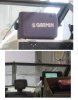
Garmin Model 2006
Never been left outside, boat stored in dry heated storage. It is the 7.2 inch grey scale screen. Very easy to see and read from.
No map chips included, takes blue chart chips which are ~75$
Has Worldwide Marine basemaps built in.
With the GPSMAP 2006 (shown) or 2006C onboard, you won't miss a thing. These chartplotters with built-in WAAS receivers can pinpoint your location to within three meters on average.
Whether you choose the 7.2-inch, crisp, 10-level grayscale, full VGA, or the 6.4-inch, 256-color TFT, you'll get outstanding contrast and resolution, even in direct sunlight. What better way to show off the built-in coastline detail and BlueChart® marine cartography available from optional data cards. This new seamless cartography from Garmin provides spot soundings, navaids, depth contours, port information and tidal predictions. The GPSMAP 2006 and 2006C are also compatible with many MapSource® products, including Fishing Hot Spots.
New cost was close to 5000$ in 2006.
700$ obo, located in duncan.
Pic shows brightness screen will get too.
Works good, comes with mount, antenna, all cables, and cover. Everything to make it go!
Garmin Model 2006
Never been left outside, boat stored in dry heated storage. It is the 7.2 inch grey scale screen. Very easy to see and read from.
No map chips included, takes blue chart chips which are ~75$
Has Worldwide Marine basemaps built in.
With the GPSMAP 2006 (shown) or 2006C onboard, you won't miss a thing. These chartplotters with built-in WAAS receivers can pinpoint your location to within three meters on average.
Whether you choose the 7.2-inch, crisp, 10-level grayscale, full VGA, or the 6.4-inch, 256-color TFT, you'll get outstanding contrast and resolution, even in direct sunlight. What better way to show off the built-in coastline detail and BlueChart® marine cartography available from optional data cards. This new seamless cartography from Garmin provides spot soundings, navaids, depth contours, port information and tidal predictions. The GPSMAP 2006 and 2006C are also compatible with many MapSource® products, including Fishing Hot Spots.
New cost was close to 5000$ in 2006.
700$ obo, located in duncan.
Pic shows brightness screen will get too.