MikePA
Well-Known Member
The only places I will bounce bottom around Nanaimo. I am too lazy to fish super deep. View attachment 89537

Is there a way to get the type of bottom displayed on navionics?
The only places I will bounce bottom around Nanaimo. I am too lazy to fish super deep. View attachment 89537

Yes. 2 versions as per below. Nautical or Sonar. Do this:Is there a way to get the type of bottom displayed on navionics?


Weird, that's the settings I have on.Yes. 2 versions as per below. Nautical or Sonar. Do this:
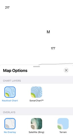
Layers. Select Nautical chart. Select No Overlay. See the depth and M for mud?
View attachment 89541
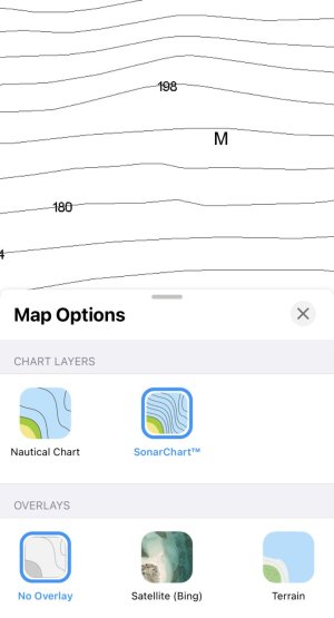
Layers. Select Sonar chart. Select No Overlay. See the depth and M for mud?
View attachment 89542
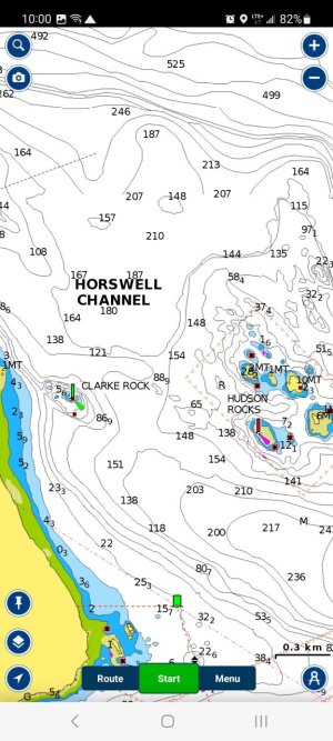
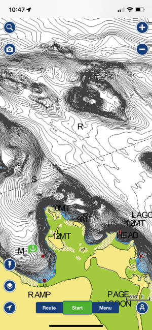
Here is your Horswell Channel area, it now shows Rock, Sand and Mud.
View attachment 89545
iPad, iPhone?Weird, that's the settings I have on.
Android phone and Android tablet, as well as a lowance plotteriPad, iPhone?
Nevermind, they are displayed.. just much smaller font. Thanks!iPad, iPhone?
Apple for the win! And you're correct, they are showing in the screenshot you posted originally.Nevermind, they are displayed.. just much smaller font. Thanks!
ThisAround Nanaimo you don't have to fish super deep - you can if you want but bait is all over the place and so are Salmon.
The picture I posted is off a free app called I-boating. I don’t have the Navionics app.View attachment 89538
Is there a way to get the type of bottom displayed on navionics?
You have to bump the hump going over the ridge at the green can.goodness… how deep are y’all bottom bouncing? i can think of two spots where i feel comfortable doing this in cr. waaaay too deep and tidal here
Do remember that Navionics charts are not super accurate. There are lots of high spots not marked and conversely flats that show with pinnacles that are not there. Watching sounder depth is key when fishing bottom if it’s a hard bottomYes. 2 versions as per below. Nautical or Sonar. Do this:
Layers. Select Nautical chart. Select No Overlay. See the depth and M for mud?
View attachment 89541
Layers. Select Sonar chart. Select No Overlay. See the depth and M for mud?
View attachment 89542
Here is your Horswell Channel area, it now shows Rock, Sand and Mud.
View attachment 89545
Good to know, I do use a modern Garmin device, but almost went with a large iPad with usb plug on the boat at first. Bottom bouncing isn't a regular thing, plus if you hit mud or sand, not a big deal.Do remember that Navionics charts are not super accurate. There are lots of high spots not marked and conversely flats that show with pinnacles that are not there. Watching sounder depth is key when fishing bottom if it’s a hard bottom
true story: last time i did that my cannon snagged bottom and i couldn’t retrieve my ball. i circled it and it came loose. on my cable was another line. after hand bombing the entire mess up i had snagged a brand new cannon, and gangion/ snubber setup.You have to bump the hump going over the ridge at the green can.
This is the ultimate in fishing success.true story: last time i did that my cannon snagged bottom and i couldn’t retrieve my ball. i circled it and it came loose. on my cable was another line. after hand bombing the entire mess up i had snagged a brand new cannon, and gangion/ snubber setup.
Yup!Around Nanaimo you don't have to fish super deep - you can if you want but bait is all over the place and so are Salmon.
That's the stage you should stay at when bottom bouncing!! LOL yes you can kind of memorize rigger settings for certain areas but that won't really be accurate because your speed and the current are never the same. I always go through the whole drill-- a bad surprise is usually very expensive!!Got out Saturday to give this a try around Entrance Island. Fished mainly around the 200' line. I was seeing fish and bait at a almost all depths so I kept one rod down close to bottom and the other I adjusted to where I was seeing more of the bait/fish. Bottom rod outfished the top 3:1 and came home with a 70cm and a 73cm on the lower.
I hadn't really thought about it, but I suppose after a while you memorize the usual depths you fish at and what DR# is associated with those depths. I'm still at the "fishing by braille" stage of my learning curve