This Notice was just posted, looks like the same as last year.
http://notices.dfo-mpo.gc.ca/fns-sap/index-eng.cfm?pg=view_notice&DOC_ID=197774&ID=all
Fishery Notice
Category(s):
RECREATIONAL - Salmon
Subject:
FN0576-RECREATIONAL - Salmon - Areas 25 to 27 and 125 to 127 - West Coast Vancouver Island Chinook Management Measures
Chinook management measures are implemented annually on the west coast of
Vancouver Island (WCVI) to reduce fishing impacts on wild WCVI chinook which
are stocks of concern while allowing harvest opportunities on passing stocks
and enhanced stocks returning to terminal areas.
The following is a description of those chinook management measures, which
include finfish closures, salmon non-retention areas and size limit
restrictions.
Please be aware that Rockfish Conservation Areas (RCAs) are also in effect in
many of these areas. Fishers are responsible for knowing the restrictions that
are in place in the areas that they are fishing. Descriptions of the RCAs can
be found on the recreational fisheries website at the address below.
http://www.pac.dfo-mpo.gc.ca/fm-gp/rec/index-eng.htm
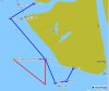
This Notice provides information for Area 25 (Nootka Sound and Esperanza
Inlet), Area 26 (Kyuquot Sound), Area 27 (Quatsino Sound) and associated
offshore waters in Areas 125 to 127.
Unless otherwise indicated below the daily limit for chinook salmon in Areas 25
to 27 and 125 to 127 is two (2) per day with a minimum size of 45 centimetres
and the possession limit is four (4).
AREAS 25 AND 125:
Effective July 15 through October 15 the following areas are closed to fishing
for all fin-fish (Fin-fish closure):
-That portion of Subarea 25-1 located northerly of a line drawn from Gauquina
point at 49 degrees 39.449'N and 126 degrees 06.040'W to a point located north
of Black Creek at 49 degrees 39.369'N and 126 degrees 05.165'W, and southerly
of a line drawn from a point at 49 degrees 36.971'N and 126 degrees 03.560'W to
a point located north of Matchlee Creek at 49 degrees 37.129'N and 126 degrees
03.006'W.
-Subareas 25-2 and 25-3.
-That portion of Subarea 25-4 inside Hisnit Inlet northwesterly of a line
beginning at 49 degrees 43.903'N and 126 degrees 29.639'W, then drawn
southwesterly across the inlet to a point located at 49 degrees 43.680'N and
126 degrees 30.322'W. Boundary signs near these locations may be erected.
-That portion of Subarea 25-5 inside Nesook Bay easterly of a line beginning at
49 degrees 46.205'N and 126 degrees 24.997'W, then drawn southerly across the
bay to a point located at 49 degrees 45.594'N and 126 degrees 25.018'W.
Boundary signs near these locations may be erected.
- That portion of Subarea 25-5 northwesterly of a line drawn between square
white fishing boundary signs on the opposite sides of the entrance to Head Bay.
-That portion of Subarea 25-8, Tahsis Inlet, north of a line beginning at the
northeastern tip of Strange Island located at 49 degrees 43.314'N and 126
degrees 37.486'W, then drawn easterly across the inlet to a point located at 49
degrees 43.315'N and 126 degrees 36.817'W.
-Subareas 25-9, 25-10, 25-11, and 25-12.
-Subareas 25-14 and 25-15 and 25-16.
-That portion of Subareas 25-13, 125-1, 125-2 and 125-3 shoreward of a line
drawn from Belmont Point located at 49 degrees 47.528'N and 126 degrees
55.605'W to a point located at 49 degrees 44.965'N and 127 degrees 01.823'W
(located approximately 1.9 nautical miles west of Ferrer Point), then
southeasterly approximately 13 nautical miles to a point located at 49 degrees
37.900'N and 126 degrees 52.600'W, then southwesterly to a point at 49 degrees
33.500'N and 126 degrees 52.600'W, then to the Red Can Buoy located at 49
degrees 33.806'N and 126 degrees 49.976'W then to a point located approximately
2 nautical miles east at 49 degrees 34.125'N and 126 degrees 46.942'W, then to
the Nootka Island shoreline at a point located near Beano Creek at 49 degrees
36.341'N and 126 degrees 45.141'W. The Bajo Reef RCA is located adjacent to
this closed area.
-That portion of Subareas 25-7, 125-1 and 125-2 inside a line beginning at a
point on Vancouver Island at 49 degrees 33.445'N and 126 degrees 33.845'W
(north of Escalante Point), then westerly to a point approximately 1 nautical
mile offshore located at 49 degrees 33.445'N and 126 degrees 35.967'W, then
southerly approximately 8.8 nautical miles to a point intersecting the Estevan
Point RCA boundary located at 49 degrees 24.688'N and 126 degrees 35.593'W,
then to a point on Vancouver Island (on Hesquiat Peninsula) at 49 degrees
25.067'N and 126 degrees 34.598'W.
AREAS 26 AND 126:
Effective July 15 through October 15 the following areas are closed to fishing
for all fin-fish (Fin-fish Closure):
-That portion of Subareas 26-1 and 26-6 shoreward of a line drawn from the
Rugged Point shoreline beginning at 49 degrees 57.618'N and 127 degrees
15.077'W to a point approximately 0.8 nautical miles south located at 49
degrees 56.904'N 127 degrees 15.677'W, then continuing approximately 5.2
nautical miles northwest to the light on Amos Island located at 50 degrees
00.768'N and 127 degrees 21.173'W, then from the northwest tip of Amos Island
at 50 degrees 01.153'N and 127 degrees 21.554'W, then to the Vancouver Island
shoreline to a point located at 50 degrees 01.368'N and 127 degrees 21.529'W.
-Subareas 26-2 to 26-5.
-That portion of Subareas 26-7 and 26-10 shoreward of a line drawn from a point
on Vancouver Island located at 50 degrees 02.149'N and 127 degrees 25.637'W,
then to a point on McLean Island located at 50 degrees 01.790'N and 127 degrees
25.556'W, then to a green navigational marker located approximately 3 nautical
miles west at 50 degrees 02.587'N and 127 degrees 29.916'W, then continuing
northwest approximately 3.2 nautical miles to Cautious Point in the Bunsby
Islands Group located at 50 degrees 04.960'N and 127 degrees 33.310'W, then
continuing northwest approximately 2.5 nautical miles to the boundary of the
Checleset Bay RCA located at 50 degrees 06.097'N and 127 degrees 36.868'W.