Suzuki 300 and Garmin

23Hourston

Well-Known Member
guys fhope ya can help
Just about to rig the new 300 fly buy wire with a
-Garmin 1042
-Garmin phantom 18
-garmin steady cast for chart overlay
-suzuki multi gauge
-Sd card
- i com 330 gps vhf for ais receiver

...All I have is what came in the boxes of these items
Do I need a NMEA back bone or any other wires to make these work. Yes I have the engine wiring harness if you were going to ask and the controls are installed.. pic is back of 1042 . I hope to avoid the old all you need is just one cable to make it all happen sorry that’s three weeks away C3B5718E-BE26-48CE-84E8-626FAE90AFED.jpegC3B5718E-BE26-48CE-84E8-626FAE90AFED.jpeg
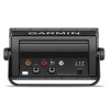
 
- radar connects via Ethernet

- heading sensor connects via NMEA2K, and yes you will need to create a N2K backbone if you don’t already have one

- I’m not familiar with Suzuki setups, but I expect the wiring harness connects to a controller / module that outputs data to the Suzuki multi gage (or connects directly). You may need to add a device if you also want to show engine data on your Garmin and this will be done via N2K. I’ll let someone else with Suzuki experience chime in here.

- icom 330 only transmits and receives data via NMEA 0183. If you want a N2K comparable VHF, you’ll have to step up to an icom 506. Also, not sure what your mean by “... for AIS receiver”. The 330 doesn’t have a built in AIS receiver (need to go to 506 again if you want that). If you are connecting to a standalone receiver with the 330, the data will have to be shared via NMEA 0183 since that is the only networking protocol the 330 supports. If you mean that you want to use the 330 for DSC calls and distress, it has a built in GPS receiver (well the 330G does, the 330 does not) so you don’t need to network to receive GPS data.
 
Thanks for the response the 1042 is both nmea 2000 and 0183 Compatible the icom is a 330g for some reason I thought it would work for ais
 
One further comment, you can connect your icom 330 to your chartplotter if you want to have some redundancy in your GPS sources (i.e. use the VHF gps info as the source for your chartplotter, or vice versa). You'll have to do this over NMEA 0183, and NMEA 0183 wiring is not as intuitive and simple as connecting to an NMEA 2K backbone (apologies if this is old news to you).

Here's a primer on NMEA 0183 connecting a garmin to icom radio that you might find useful.

 
I highly recommend going the NMEA 2K route, especially from the motor.

If the Suzuki's are like Yamahas, if you want fuel flow/econ data you'll need NMEA 2K and a backbone. You can then get fuel econ data on the plotter display since it will use the GPS speed and fuel flow data to give a more accurate number than what the motor gauges could ever tell you from the the analog pitot tube sensor on the outboard (which is usually plugged and unreliable). You also would then have redundancy on fuel level in case your sending unit goes out.
 
Back
Top