Sharphooks
Well-Known Member
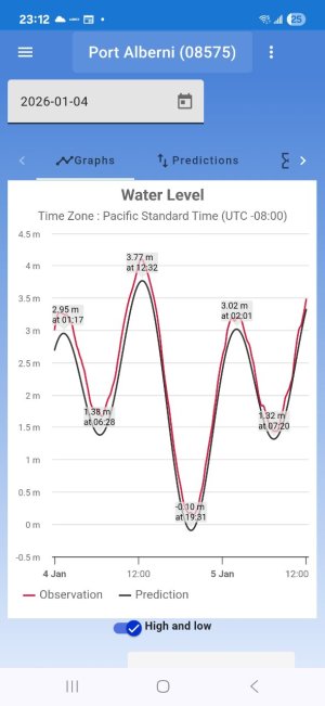
I was surprised to see people remarking in a YT video that the King Tides in Port Alberni were the “highest they’d seen in 10 years”.
Question: Does anybody know what the barometric pressure was in Port Alberni on 03/04 January?
Reason I’m asking:
In 2022 we had King Tides in my neighborhood just after Christmas. The stated high tide was 12.5 feet and at the peak of that tide it put 1 1/2 meters of water in my back yard and about 15 cm into my house


So this past Sunday we had a 13 foot tide, approx. 15 cm HIGHER then the KIng Tide we had in 2022 that destroyed all that property in my neighborhood
So why did I go to bed Saturday night being quite confident that my house wouldn’t get water intrusion from what would be a much higher tide?
Barometric pressure.
In 2022 the barometer reading was 28.5 inches of mercury. That differential below normal sea level barometric pressure, based on the inverse calculation that for every millibar of pressure below normal sea level barometric pressure (1,1013 millibars or approx. 29.9 inches of mercury) we get an approx. one (1) centimeter rise in water level
If you do the math, that 28.5 inches of mercury in 2022 represented a 48 centimeter (!!!!) rise of sea level. So a 12.5 foot tide turned into a 14 foot tide. Add a bit of wave action and the water level in some places was measured at 15 feet above normal sea level
Last Saturday night I took note that the barometric pressure was approx. 29.4. I calculated that worst case that 13 foot tide last Sunday would turn into a 13’ 7” tide and would probably put my dock under water by approx. 4 cm but the water wouldn’t come into my yard
I woke up at 6:30 Sunday morning at the peak of the tide and saw by flashlight that my calculation was almost exact. And so it was Monday and this morning, three 13 foot tides in a row that were harmless (a steady rising barometer saved the day)
So that’s why I ask about the barometer in Port Alberni. I’m not sure the tidal readouts would have been all that different from what we had and what Port ALberni had so to have gotten all that water in the CLutesi parking lot that had people hyperventilating that it was the biggest tide they’d seen in 10 years, there must have been a big dip in barometeric pressure
Can anybody confirm what it was?
Question: Does anybody know what the barometric pressure was in Port Alberni on 03/04 January?
Reason I’m asking:
In 2022 we had King Tides in my neighborhood just after Christmas. The stated high tide was 12.5 feet and at the peak of that tide it put 1 1/2 meters of water in my back yard and about 15 cm into my house
So this past Sunday we had a 13 foot tide, approx. 15 cm HIGHER then the KIng Tide we had in 2022 that destroyed all that property in my neighborhood
So why did I go to bed Saturday night being quite confident that my house wouldn’t get water intrusion from what would be a much higher tide?
Barometric pressure.
In 2022 the barometer reading was 28.5 inches of mercury. That differential below normal sea level barometric pressure, based on the inverse calculation that for every millibar of pressure below normal sea level barometric pressure (1,1013 millibars or approx. 29.9 inches of mercury) we get an approx. one (1) centimeter rise in water level
If you do the math, that 28.5 inches of mercury in 2022 represented a 48 centimeter (!!!!) rise of sea level. So a 12.5 foot tide turned into a 14 foot tide. Add a bit of wave action and the water level in some places was measured at 15 feet above normal sea level
Last Saturday night I took note that the barometric pressure was approx. 29.4. I calculated that worst case that 13 foot tide last Sunday would turn into a 13’ 7” tide and would probably put my dock under water by approx. 4 cm but the water wouldn’t come into my yard
I woke up at 6:30 Sunday morning at the peak of the tide and saw by flashlight that my calculation was almost exact. And so it was Monday and this morning, three 13 foot tides in a row that were harmless (a steady rising barometer saved the day)
So that’s why I ask about the barometer in Port Alberni. I’m not sure the tidal readouts would have been all that different from what we had and what Port ALberni had so to have gotten all that water in the CLutesi parking lot that had people hyperventilating that it was the biggest tide they’d seen in 10 years, there must have been a big dip in barometeric pressure
Can anybody confirm what it was?
Last edited: